GTA 6 Map vs Florida: How Leonida Compares to the Real Sunshine State
When comparing the GTA 6 map vs Florida, the short answer is that Leonida is a concentrated, unevenly compressed remix of Florida—not a 1:1 geographical replica. Rockstar Games took a real U.S. state spanning 170,312 km² (65,758 sq mi) and distilled its most dramatic biomes into a seamless open world measuring roughly 175 km² (67.5 sq mi) across its pause-map footprint (about 98–114 km² of playable land, or ~2× the size of GTA 5). Vice City mirrors Miami, the Leonida Keys echo the Florida Keys, Grassrivers recreates the Everglades, and Ambrosia channels Lake Okeechobee's sugar belt—while the 300-mile western Panhandle is folded onto the west coast around Port Gellhorn, standalone cities like Orlando and Jacksonville are omitted, and steep canyons rise along the northern border in Mount Kalaga National Park.
Explore the Detailed Comparison Interactively: This guide breaks down the macro geography, scale math, highways, five official counties, and signature landmarks behind Leonida. To switch between the
2 px/mIn-Game Map (Day) tileset and community editions, filter 3,749 locations (including 385 enterable buildings), and inspect dual in-game[X, Y]and real-world Florida GPS coordinates across 1,996 places, open our interactive GTA 6 map comparison on the homepage.
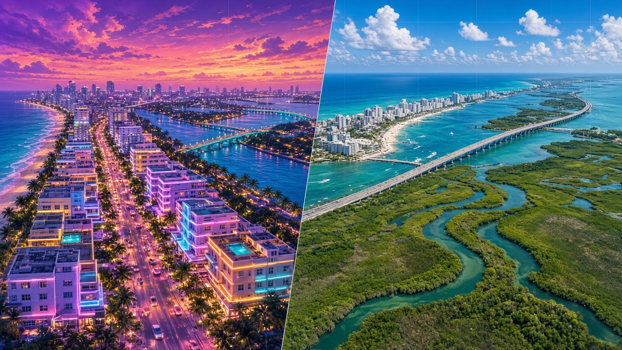
Quick Verdict: GTA 6 Leonida vs. Real-World Florida at a Glance
Before diving into each region and highway corridor, here is how the shipped State of Leonida stacks up against official U.S. Census Bureau, USGS, and National Park Service figures for Florida:
| Dimension / Feature | Real-World Florida (USGS / Census) | GTA 6: State of Leonida | Key Takeaway |
|---|---|---|---|
| Official Name & Nickname | State of Florida ("The Sunshine State") | State of Leonida ("The Goodtime / Sunshine State") | Named after Spanish explorer Juan Ponce de León |
| Total Surface Footprint | 170,312 km² (65,758 sq mi) | ~175 km² (67.5 sq mi pause-map box)* | Real Florida is roughly 970×–1,600× larger in area |
| Dry Land Area | 138,887 km² (53,625 sq mi) | ~98–114 km² (38–44 sq mi, community/guide est.)* | Roughly 2× GTA 5's land and 3× RDR2's playable world |
| Water Surface Share | 18.4% (31,424 km² inland + coastal) | ~35% (bays, straits, reefs, swamps & Lake Leonida) | Nearly double Florida's water ratio to support boats & diving |
| North–South × East–West Span | 720 km × 581 km (447 mi × 361 mi) | ~16 km × 10.9 km (9.9 mi × 6.8 mi) | No 300-mile western Panhandle sticking out |
| End-to-End Highway Drive | ~11 hr 30 min (792 mi, Pensacola to Key West) | 10 min 53 sec (south-to-north highway run) | Walking takes 3h 21m; flying takes 5m 51s (Kotaku test) |
| Administrative Counties | 67 Counties | 5 Pause-Map Counties (+ Ambrosia on local signs) | Vice-Dale, Mariana, Kelly, Leonard, Lummox |
| Primary Metropolis | Miami Metro (~6.1M pop.) + Orlando, Tampa, Jax | Vice City (only major metropolis; ~2× Los Santos) | Other regions feature working ports, mill towns & resorts |
| Highest Natural Elevation | Britton Hill — 105 m (345 ft) (flattest U.S. state) | Mount Kalaga National Park (steep peaks & canyons) | Rockstar borrowed Georgia-style canyons for verticality |
| Neighboring Northern State | Georgia | Gloriana (seen on border lore & license plates) | Mount Kalaga sits along the Leonida–Gloriana line |
*Note on scale figures: Rockstar Games does not publish official square-kilometer totals; it describes Leonida as roughly twice GTA 5's map, three times Red Dead Redemption 2's, and nearly equal in landmass to GTA 4 + GTA 5 + RDR2 combined (Edge #430). Square-kilometer figures come from launch-week in-game pause-map measurements (~175 km² total frame, ~65% land) and community grid measurements (~85.6–98 km² pure dry land).
1. Shape & Geography: Why Isn't the GTA 6 Map Shaped Like Real Florida?
One of the most common questions from players searching gta6 map vs florida is why Leonida's coastline looks thicker, boxier, and lacks Florida's unmistakable western Panhandle.
If Rockstar had traced Florida's exact silhouette at video-game scale, two major design problems would have ruined pacing:
- A 300-mile narrow Panhandle corridor would force players onto a dead, isolated highway strip disconnected from the rest of the map.
- Hundreds of miles of flat central scrubland and pine ranching between Miami, Lake Okeechobee, and North Florida would turn every cross-state mission into monotonous straight-line freeway driving.
As Rockstar North co-studio head Rob Nelson explained in pre-launch hands-on coverage (TROISCOULEURS), the environment team anchored the core landmarks where they belong relative to Miami, then squeezed the dead space between them to create "a warped sort of version of reality—not one-to-one life-size."
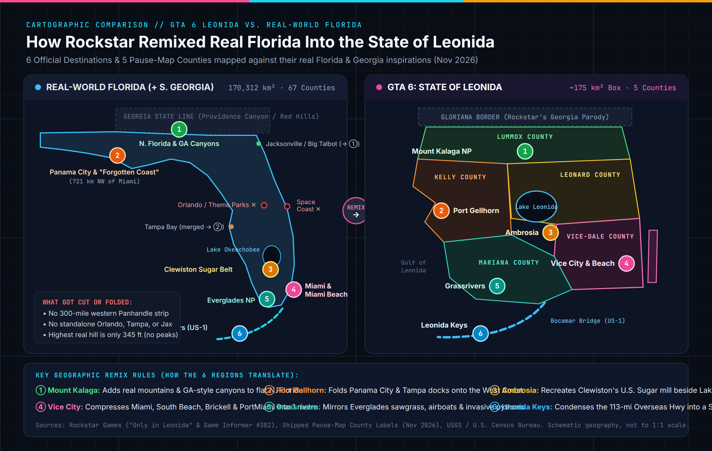
Here are the four biggest structural changes Rockstar made when reshaping Florida into Leonida:
- Folding the Panhandle onto the West Coast: Instead of extending westward toward Alabama, Rockstar tucked Panhandle inspirations—like Panama City, Apalachicola's "Forgotten Coast," and Port Tampa Bay's industrial cranes—onto Leonida's western Gulf shoreline around Port Gellhorn.
- Inventing Real Mountains in the North: Real Florida is famously the flattest state in America; its highest natural point, Britton Hill in Walton County, rises just 345 feet (105 meters) above sea level. To give off-road vehicles, dirt bikes, base jumpers, and hunters dramatic elevation, Rockstar built Mount Kalaga National Park and Manifest Canyon across northern Lummox County by blending North Florida's Tallahassee Red Hills and Torreya bluffs with Providence Canyon across the Georgia (Gloriana) border.
- Doubling the Water-to-Land Feel (35% vs. 18.4%): Water accounts for roughly 35% of Leonida's map sheet. Between Lake Leonida (Lake Okeechobee) in the interior, coastal bays and barrier islands in the east, mangrove channels across Grassrivers, and deep-water straits around the Leonida Keys, ferries, fanboats, jet skis, and seaplanes are genuine transit alternatives to highways.
- Eliminating GTA 5's "Single Loop Highway" Problem: GTA 5 funneled nearly every long drive onto one oval freeway circling Mount Chiliad. Leonida replaces that single ring road with a web of crisscrossing causeways, inland truck routes, and coastal state roads connecting smaller towns—making Vice City and its surrounding suburbs dramatically denser in built-up footprint than Los Santos.
2. Scale & Rockstar's "Radial Compression" Trick Explained
Comparing raw square mileage between a real U.S. state and a handcrafted open-world game always produces a dramatic ratio: real Florida's dry land (138,887 km²) is roughly 1,200 to 1,620 times larger than Leonida's playable land (~86–114 km²).
Yet anyone playing GTA 6 immediately notices that Vice City feels genuinely metropolitan—and that is because Rockstar did not shrink Florida uniformly.
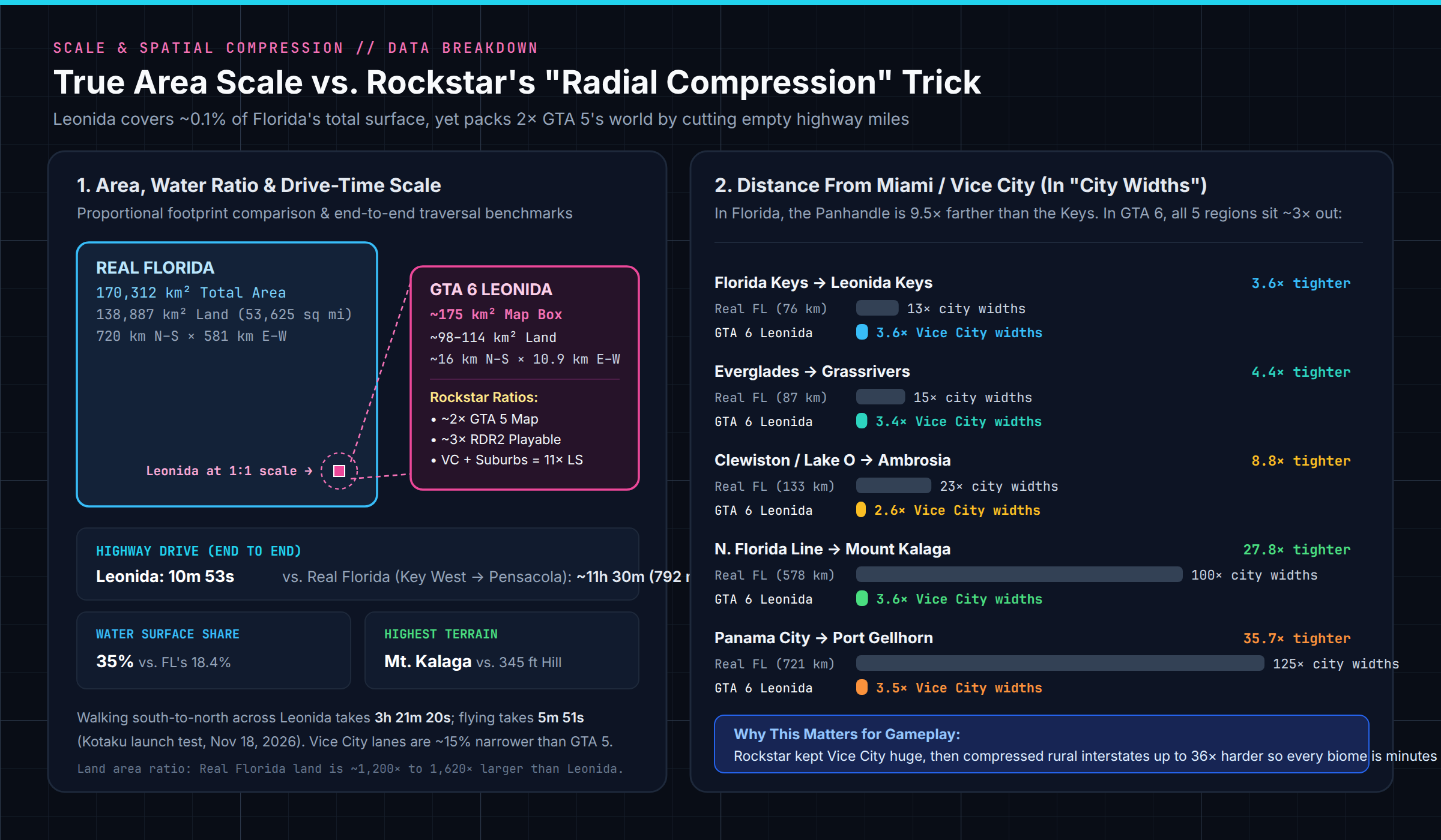
How Uneven Compression Works (Measured in "City Widths")
Independent spatial analysis across 55 dual-coordinate landmarks (comparing real GPS coordinates in Florida against mapped positions in Leonida) reveals Rockstar's radial layout secret:
| Outlying Region | Real Florida Prototype | Real Distance From Miami | Distance in Real "Miami Widths" | Distance in GTA 6 "Vice City Widths" | Compression Intensity |
|---|---|---|---|---|---|
| Leonida Keys | Florida Keys (Key Largo–Key West) | ~76 km | 13.0× | 3.6× | 3.6× tighter |
| Grassrivers | Everglades National Park | ~87 km | 15.0× | 3.4× | 4.4× tighter |
| Ambrosia | Clewiston & Lake Okeechobee | ~133 km | 23.0× | 2.6× | 8.8× tighter |
| Mount Kalaga | North Florida / Georgia Line | ~578 km | 100.0× | 3.6× | 27.8× tighter |
| Port Gellhorn | Panama City / Forgotten Coast | ~721 km | 125.0× | 3.5× | 35.7× tighter |
Look at the last two columns:
- In real Florida, Panama City Beach (721 km northwest of Miami) is 9.5 times farther away than Key Largo (76 km south).
- In GTA 6's Leonida, Port Gellhorn (3.5×) and the Leonida Keys (3.6×) sit at virtually the exact same distance from Vice City—and so do Grassrivers (3.4×), Ambrosia (2.6×), and Mount Kalaga (3.6×).
Meanwhile, inside Vice City itself, Rockstar North made traffic lanes ~15% narrower than GTA 5's overly wide streets (as Rob Nelson noted to ZEIT and Famitsu), matching real Miami lane proportions so more city blocks, alleys, and 385 enterable storefronts, hotel lobbies, and rooftops fit per square kilometer. Combined with seamless elevators, Vice City retains metropolitan density while placing five distinct ecosystems within a 3-to-5-minute drive of downtown.
3. Region-by-Region Breakdown: All 6 Leonida Destinations vs. Real Florida
Rockstar spotlights six flagship regions on its Only in Leonida destination hub, spread across five administrative counties printed on the in-game pause map (Vice-Dale, Mariana, Kelly, Leonard, and Lummox). Here is how every region compares to the real Sunshine State.
3.1 Vice City & Vice Beach (Vice-Dale County) ↔ Miami & Miami Beach
- Rockstar's Tagline: "Everything in Excess — still the sun and fun capital of America."
- Real-World Match Confidence: Direct & Official.
- How It Compares: Unlike 2002's GTA: Vice City (which only had two flat islands set in 1986), GTA 6 rebuilds modern-day Miami-Dade County (
Vice-Dale County) from the ground up in Vice City & Vice Beach:- Ocean Beach & Washington Beach (
Vice Beach) mirror South Beach's Art Deco Historic District (Ocean Drive, Collins Avenue, pastel neon hotels, beachfront gyms, and lifeguard stands). - Downtown & Crosstown fuse Downtown Miami and Brickell's glass condo towers, elevated Metromover tracks, and bayfront expressway interchanges.
- Little Cuba channels Little Havana and Calle Ocho (SW 8th Street), complete with panaderías, domino parks, and murals under expressway overpasses.
- Stockyard parodies Wynwood's converted meatpacking warehouses and street-art walls.
- Port Vice City directly echoes PortMiami, trading Miami-Dade's registered slogan "Cruise Capital of the World" for "the cruise ship capital of the world."
- Starfish Island, Rialto Islands & Leaf Links recreate Biscayne Bay's artificial millionaire enclaves—Star Island, the Venetian Islands, and Indian Creek Country Club ("Billionaire Bunker").
- Ocean Beach & Washington Beach (
3.2 Leonida Keys (Mariana & Vice-Dale Counties) ↔ The Florida Keys
- Rockstar's Tagline: "Gateway to Paradise — life in this tropical archipelago isn't flashy, but it's easy."
- Real-World Match Confidence: Direct & Official.
- How It Compares: Stretching off Leonida's southern coast across
Leonida StraitsandLeonida Bay, the Leonida Keys mirror Monroe County's 113-mile Florida Keys chain:- Linked by U.S. Route 1 and the sweeping Bocamar Bridge (modeled on the Seven Mile Bridge and the broken rail span of the Old Bahia Honda Bridge).
- Key Lento (where Jason Duval begins the story) blends Key Largo and Islamorada, right down to echoing Key Largo's highway welcome sign and waterfront dive bars.
- At the far southern tip sits Mile Zero Air Station, a direct nod to Naval Air Station Key West (Boca Chica Field) and Key West's famous Mile Marker 0 at the end of US-1.
- Underwater, the archipelago mirrors NOAA's Florida Keys National Marine Sanctuary—North America's only living coral barrier reef—supporting scuba diving among sea turtles, sharks, and shipwrecks.
3.3 Grassrivers (Mariana County) ↔ The Everglades & Big Cypress
- Rockstar's Tagline: "Welcome to the Wetlands — the untamable jewel of Leonida's crown."
- Real-World Match Confidence: Direct & Official (confirmed by Rockstar devs to Game Informer).
- How It Compares: Even the name Grassrivers is a literary tribute to conservationist Marjory Stoneman Douglas's landmark 1947 book, The Everglades: River of Grass.
- Spans sawgrass prairies, cypress domes, mangrove tunnels, stiltsville shacks, and airboat tour docks mirroring Shark River Slough and the Tamiami Trail.
- Rockstar's line warning of "far deadlier predators and weirder discoveries among the mangroves" reflects two real National Park Service facts: South Florida is the only place on Earth where American alligators and American crocodiles coexist, and the Everglades is ground zero for invasive Burmese pythons.
3.4 Port Gellhorn (Gulf Coast) ↔ Panama City, "Forgotten Coast" & Tampa Bay
- Rockstar's Tagline: "Live Hard — Leonida's forgotten coast."
- Real-World Match Confidence: Composite Remix (Developer-cited scouting + Gulf Coast fusion).
- How It Compares: Port Gellhorn is Rockstar's sharpest geographical mashup. On one hand, "Forgotten Coast" is the actual tourism slogan of Franklin County (Apalachicola / St. George Island) in the Florida Panhandle—except while real Franklin County advertises quiet beaches, Rockstar flips the joke into a faded Spring Break strip of pawn shops, hourly motels (Starlet Motel), shut-down attractions, malt liquor, and truck-stop energy drinks reminiscent of older stretches of Panama City and Pasco/Pinellas US-19. On the industrial waterfront, mappers also matched container cranes and bay bridges borrowed straight from Port Tampa Bay and the Sunshine Skyway.
3.5 Ambrosia & Lake Leonida ↔ Clewiston & Lake Okeechobee
- Rockstar's Tagline: "Keeping Leonida Sweet — American industry and old school values."
- Real-World Match Confidence: Strong Thematic & Structural Match.
- How It Compares: Anchoring Leonida's interior near Lake Leonida (Florida's 700-sq-mi Lake Okeechobee), Ambrosia is a dead ringer for Clewiston in Hendry County:
- Clewiston's real-life town motto is literally "America's Sweetest Town," dominated by sprawling U.S. Sugar refinery smokestacks and burning sugarcane fields.
- GTA 6 turns U.S. Sugar into the Allied Crystal Sugar Refinery, adding an outlaw biker gang chapter that controls the blue-collar town's underground economy.
3.6 Mount Kalaga National Park (Lummox County) ↔ FL–GA Border, Ocala & Providence Canyon
- Rockstar's Tagline: "Wild, Wild Country — room to breathe on the state's northern fringes."
- Real-World Match Confidence: Artistic Departure + Real North FL/GA Scouting.
- How It Compares: Located across northern Lummox County, Mount Kalaga National Park represents the cultural borderland of the Florida–Georgia Line (called the Leonida–Gloriana Line in-game). Rockstar SVP of Environment Art Paul MacPherson told Game Informer (#382) that his team scouted Jacksonville, Ocala, Panama City, lumber zones, private-airstrip gated communities, and "BlackRock- and boneyard-inspired beaches" (matching Big Talbot Island State Park near Jacksonville), then added steep rust-red ravines inspired by Georgia's Providence Canyon so players get whitewater kayaking, cougar hunting, and mountain switchbacks that flat Florida lacks in real life.
4. Counties, Highways & Waterways: Decoding Florida's Infrastructure
One detail that trips up many players inspecting the GTA 6 in-game pause map is why there are 5 counties on the map (Vice-Dale, Mariana, Kelly, Leonard, Lummox) when Rockstar promotes 6 regions.
The answer mirrors real Florida civics: Counties are administrative and sheriff jurisdictions, while Regions are geographic/tourism destinations. Even better, Rockstar hid a sharp Florida geography Easter egg inside Mariana County: players wondered why both the southern Leonida Keys and the swampy Grassrivers belong to Mariana County—until Floridians pointed out that in real life, Monroe County encompasses both the entire Florida Keys island chain and a massive mainland slice of Everglades National Park.
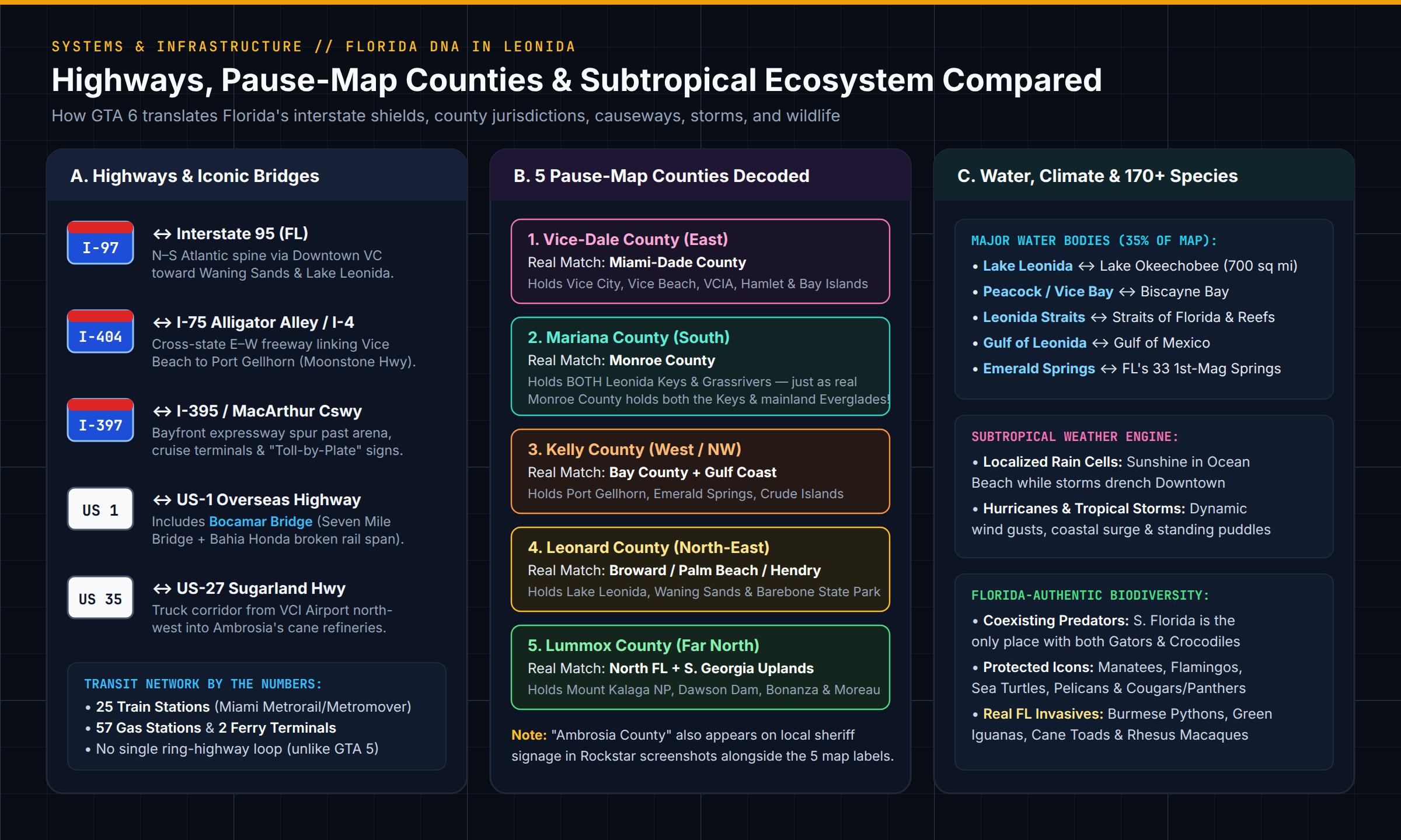
Florida Highway Shields vs. GTA 6 Road Corridors
- Interstate 97 (
I-97) ↔ Interstate 95 (I-95): The primary north–south coastal superhighway cutting right through Downtown Vice City and continuing north toward Waning Sands and Lake Leonida. - Interstate 397 (
I-397) ↔ Interstate 395 (I-395/ MacArthur Causeway): The iconic bayfront spur linking Downtown's arena and cruise terminals across the water to Ocean Beach—complete with replicas of Florida's "OR TOLL BY PLATE" overhead gantries. - Interstate 404 (
I-404) ↔ Interstate 75 (Alligator Alley) / I-4: The main east–west cross-state artery spanning Leonida from Vice Beach all the way to Port Gellhorn's Gulf highway corridor. - U.S. Route 1 (
US 1) & Bocamar Bridge ↔ U.S. Route 1 (Overseas Highway & Seven Mile Bridge): The linear ocean causeway stringing together Key Lento, the southern keys, and Mile Zero Air Station. - U.S. Route 35 (
US 35) ↔ U.S. Route 27 (Sugarland Highway): The heavy freight corridor running northwest past Vice City International Airport (VCIA) into Ambrosia's cane fields.
5. Iconic Real-Life Florida Landmarks vs. GTA 6 Counterparts
Across Vice City and Leonida, Rockstar's environment artists recreated hundreds of real-life Florida landmarks, bridges, arenas, hotels, and roadside oddities—keeping their recognizable silhouettes intact while twisting their names with classic Rockstar satire.
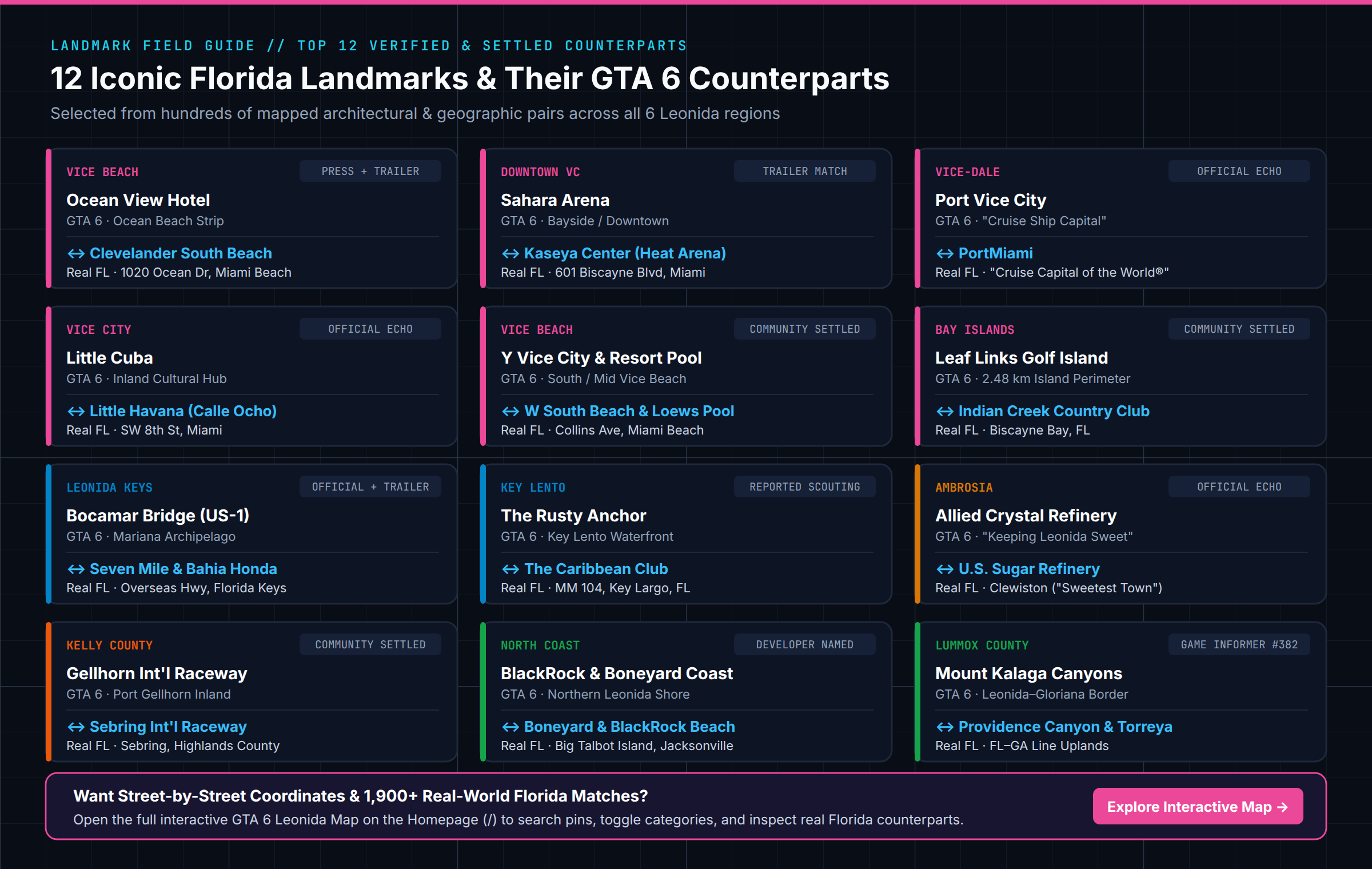
Here are 15 high-confidence landmark matches spanning every corner of the map:
| GTA 6 Landmark | Leonida Location | Real Florida Counterpart | Real City, FL | Match Basis |
|---|---|---|---|---|
| Ocean View Hotel | Ocean Beach, Vice Beach | Clevelander South Beach (+ Colony Hotel neon) | Miami Beach | Returning icon + Trailer 1 & 2 |
| Y Vice City | Washington Beach, Vice Beach | W South Beach | Miami Beach | Settled architectural & enterable match |
| Vice Regal Hotel | Washington Beach, Vice Beach | Bal Harbour Beachfront Tower | Bal Harbour | Settled coastline skyline match |
| Sahara Arena | Bayside / Downtown VC | Kaseya Center (Miami Heat Arena) | Downtown Miami | Waterfront bowl + skyline position |
| Megamundo Tower | Downtown Vice City | One Biscayne Tower | Downtown Miami | Settled skyline match |
| Arcadia Towers (N & S) | Downtown Vice City | Vizcayne North & South Condos | Downtown Miami | Twin high-rise facade match |
| Akio Hotel | Tequesta Retreat, VC | Mandarin Oriental (Brickell Key) | Miami | Island hotel geometry match |
| Port Vice City | Vice-Dale County | PortMiami ("Cruise Capital of the World") | Miami | Official Rockstar description |
| VCIA | West Vice-Dale County | Miami International Airport (MIA) | Miami | Highway signs + terminal layout |
| Leaf Links | Vice Bay Island | Indian Creek Country Club | Indian Creek, FL | 2.48 km gated golf island match |
| Bocamar Bridge | U.S. Route 1, Keys | Seven Mile Bridge & Old Bahia Honda Span | Marathon / Big Pine Key | Trailer flyovers + Route 1 |
| The Rusty Anchor | Key Lento, Mariana | The Caribbean Club (1948 Key Largo bar) | Key Largo | Reported scouting + exterior match |
| Allied Crystal Refinery | Ambrosia | U.S. Sugar Clewiston Refinery | Clewiston | Official Rockstar Only in Leonida |
| Gellhorn Int'l Raceway | Port Gellhorn | Sebring International Raceway | Sebring | Track layout & signage match |
| Watson Bay | West Coast | Cedar Key | Levy County | 33 matched coastal structures |
Want to Browse All 1,996 Real-World Florida Coordinate Matches? Listing every building in one article would take 50 pages. On our Homepage Interactive GTA 6 Map, 1,996 of the 3,749 mapped locations carry dual in-game
[X, Y]and real-world Florida GPS coordinates across 5 switchable tilesets—click any pin to inspect its exact street-level counterpart in Leonida.
6. Are Orlando, Disney World, Tampa, Jacksonville, or Cape Canaveral in GTA 6?
Because Florida has four major metro areas in real life—Miami, Orlando, Tampa Bay, and Jacksonville—players frequently ask whether central and northern cities appear on the GTA 6 map. Based on the shipped pause map and Game Informer's September 2026 interview with Rockstar SVP of Environment Art Paul MacPherson, here is the exact status of every "missing" Florida city:
- Is Orlando, Disney World, or Universal Studios in GTA 6? Not as a standalone city or giant theme-park resort. When asked directly about Orlando's theme parks and SeaWorld, MacPherson explained that Rockstar evaluates landscapes, towns, and landmarks and distills what serves the narrative: "While we may not have those exact locations, everything we have is geared to getting that full Florida experience." Instead of a sprawling Fairyland resort, Central Florida's tourist-trap kitsch shows up in roadside alligator attractions (resembling Gatorland), miniature golf, and faded highway amusements.
- Is the Space Coast / Kennedy Space Center (Cape Canaveral) in GTA 6? No standalone rocket launch complex appears on the northeastern coast. Northeast Leonida transitions from Waning Sands and coastal state parks into rural Lummox County bays rather than a NASA launch pad parody.
- Is Tampa or St. Petersburg in GTA 6? No city named Tampa exists, but Tampa Bay's DNA is baked into Port Gellhorn. Western Leonida absorbs Tampa's industrial container port, bay bridges, and Gulf strip-mall sprawl alongside Panama City's beach motel culture.
- Is Jacksonville or Tallahassee in GTA 6? No second big northern metropolis exists—Vice City is Leonida's sole major city. However, Rockstar confirmed scouting Jacksonville, Ocala, and North Florida rural towns extensively, bringing Big Talbot Island's driftwood-strewn Boneyard Beach, Ocala's horse ranches, floodlit demolition-derby ovals, logging camps, and private-jet fly-in communities into Northern Leonida.
- Is Key West in GTA 6? Yes, in condensed form. The southernmost islands of the Leonida Keys feature conch-style wooden bungalows, sunset piers, roosters and iguanas on the streets, and Mile Zero Air Station, capturing Key West's unmistakable end-of-the-road atmosphere.
7. Beyond Geography: How GTA 6 Captures "Florida Man" Culture, Weather & Wildlife
What ultimately makes Leonida feel indistinguishable from Florida isn't coastline geometry—it is the living atmospheric and ecological simulation layered onto the map:
- Localized Subtropical Storms & Hurricanes: Built by VP of Lighting & Rendering Owen Shepherd's team, Leonida models Florida's convective sea-breeze weather. You can stand under bright sunshine on Vice Beach while watching a dark thunderhead dump rain over Downtown towers across the bay, leaving realistic standing puddles afterward—all the way up to full tropical storms and hurricanes.
- 170+ Native & Invasive Florida Species: Rockstar VP of Dynamic Art Michael Kane confirmed over 170 animal species across land, sea, and sky. Alongside native icons (alligators, crocodiles, West Indian manatees, American flamingos, pelicans, sea turtles, white-tailed deer, and Florida panthers/cougars), Leonida specifically simulates Florida's notorious invasive species crisis: Burmese pythons in Grassrivers, green iguanas sunning on Keys seawalls, cane toads, and even feral rhesus macaques (a direct nod to Silver Springs State Park's famous wild monkey colony in Marion County).
- "America Dialed Up to 11": Co-studio head Aaron Garbut summed up why Rockstar chose Florida for its most ambitious world ever: "Florida is America dialed up to 11." From airboat gator hunters and viral Ocean Beach street scenes to fly-in millionaire enclaves minutes away from muddy ATV parks, Leonida compresses every extreme of modern Florida life into a single seamless map.
Compare Every GTA 6 Location Against Real Florida on Our Interactive Map
Reading about how Rockstar squeezed 170,000+ square kilometers of Florida into Leonida gives you the macro picture—but seeing how the roads, 5 counties, islands, and 3,749 mapped landmarks actually connect is best done hands-on.
Launch the Full Interactive GTA 6 Map & Detailed Florida Comparison on the Homepage (/)
- Switch Across 5 Map Versions: Toggle instantaneously between the native
2 px/mIn-Game Map (Day) pause-menu tileset and four historic community maps (Yanis v18,Yanis v18 + Sub-Maps,Yanis v15, andDupzor v51). - Inspect Dual In-Game & Real Florida Coordinates: Click pins across Vice City, Vice Beach, Port Gellhorn, Grassrivers, Leonida Keys, Ambrosia, and Mount Kalaga to compare Leonida
[X, Y]coordinates with 1,996 real-world Miami & Florida GPS counterparts. - Filter Enterable Interiors & Track Progress: Isolate all 385 enterable buildings, filter 18 categories, drop custom markers, and save your checklist directly in your browser on desktop, iPhone, or Android—no account required.
Editorial Note: This guide is an independent geographic analysis comparing Rockstar's shipped world, developer interviews (Game Informer #382, Edge #430), and community cartography (gtadb.org, CC BY 4.0) with public U.S. Census, USGS, NOAA, and National Park Service data for Florida.
Frequently Asked Questions
Is the GTA 6 map a 1:1 recreation of Florida?
No. GTA 6 takes place in the fictional State of Leonida, which is heavily inspired by Florida but compressed and reshaped for gameplay. Real Florida covers 170,312 km² (65,758 sq mi), whereas Leonida's in-game pause map spans roughly 175 km² (67.5 sq mi) including water (~98–114 km² of land)—making it roughly twice the size of GTA 5 while cutting out hours of empty highway driving.
Why doesn't the GTA 6 map have the Florida Panhandle?
A realistic 300-mile western Panhandle would create a long, isolated dead-end corridor. Instead, Rockstar folded Panhandle inspirations—such as Panama City and Franklin County's 'Forgotten Coast' nickname—onto Leonida's western Gulf coast around Port Gellhorn, blending them with port elements from Tampa Bay.
Why does GTA 6 have mountains in Mount Kalaga when Florida is flat?
Real Florida's highest natural point (Britton Hill) reaches only 345 feet (105 m). Rockstar created Mount Kalaga National Park along Leonida's northern border with Gloriana (Georgia) by combining North Florida's Tallahassee Red Hills and river bluffs with Georgia's Providence Canyon so players get steep elevation for dirt bikes, kayaking, and cougar hunting.
Which real-life Florida cities are in GTA 6?
Miami and Miami Beach are recreated as Vice City and Vice Beach (the game's only major metropolis). Key Largo through Key West appear as the Leonida Keys, Clewiston appears as Ambrosia, Panama City and Tampa Bay inspire Port Gellhorn, and Cedar Key inspires Watson Bay. Standalone replicas of Orlando, Jacksonville, and Tallahassee are omitted.
How long does it take to drive across Leonida compared to real Florida?
Driving from Pensacola to Key West in real Florida covers 792 miles and takes roughly 11.5 hours nonstop. In GTA 6, a south-to-north highway drive across Leonida takes 10 minutes and 53 seconds, walking takes 3 hours and 21 minutes, and flying takes 5 minutes and 51 seconds.
How can I see exact GTA 6 locations matched with real Florida landmarks?
Open our interactive GTA 6 map on the homepage (/) to switch between the 2 px/m In-Game Day tileset and community maps, filter 3,749 mapped places, and inspect dual in-game [X, Y] and real-world Miami/Florida GPS coordinates across 1,996 locations.
Player comments
Comments
No comments yet. Spotted a missing or misplaced location? Leave the name and area and we will check it.